
Stepping onto your own boat for the first time, whether it’s a nimble sailboat or a powerful motor yacht, is an exhilarating experience. But let’s be honest, that feeling of freedom can quickly turn to anxiety if you’re not sure exactly where you are or where you’re going. That’s where a dedicated marine GPS comes in – it’s not just a fancy gadget; it’s truly your eyes and ears on the water, an indispensable tool for boat navigation.
Table Of Content
- Why a Dedicated Marine GPS Isn’t Just a “Nice-to-Have”
- Understanding the Core Features: What Really Matters
- Display Size and Clarity
- Chart Capabilities
- GPS Accuracy and Speed
- Connectivity and Integration
- User Interface and Ease of Use
- Types of Marine GPS Units: From Handheld to Integrated Systems
- Handheld GPS
- Fixed-Mount Chartplotters
- Multi-Function Displays (MFDs)
- Installation, Power, and Data: Getting It All Connected
- Beyond the Purchase: Charts, Updates, and Best Practices
Forget relying solely on your phone. While useful in a pinch, a robust, purpose-built marine GPS unit offers reliability, accuracy, and features that consumer devices simply can’t match in a demanding marine environment. If you’re pondering your first purchase, you’re in the right place. As someone who’s spent decades helping fellow enthusiasts find their way, I’m here to guide you through selecting the perfect marine electronics to ensure safe and enjoyable voyages.
Why a Dedicated Marine GPS Isn’t Just a “Nice-to-Have”
When you’re out on the water, knowing your exact position is paramount. A dedicated marine GPS provides that crucial information constantly, even if cell service drops or Wi-Fi is nonexistent. These units are built to withstand the elements – salt spray, direct sun, vibration – things that would quickly sideline a smartphone or tablet. Plus, they run on your boat’s power, eliminating battery life worries when you need them most.
Honestly, I’ve seen too many situations where folks thought their phone app would suffice, only to find themselves scrambling. For example, imagine this situation: a thick fog rolls in unexpectedly as you’re returning to port. Visibility drops to mere yards, and suddenly that familiar coastline disappears. Without a reliable chartplotter showing your precise location relative to the channel markers, shallows, and other vessels, navigating safely becomes incredibly stressful, even dangerous. This is where a dedicated marine GPS shines, guiding you home with unwavering accuracy.
Understanding the Core Features: What Really Matters
So, you’re convinced you need one. But what specific GPS features should you prioritize? Let’s break down the essentials that will make the biggest difference in your boating experience.
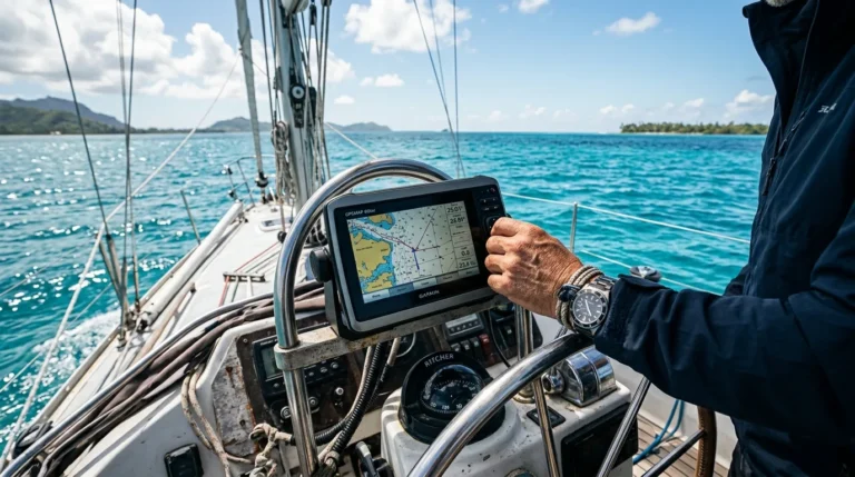
Display Size and Clarity
This is often the first thing people notice, and for good reason. A larger screen (think 7-inch to 12-inch for most recreational boats) makes reading charts, waypoints, and other data much easier, especially from a distance or in choppy conditions. Look for displays with high resolution and excellent brightness, designed for direct sunlight viewing. You want crisp, clear images, not something you have to squint at while battling glare.
Chart Capabilities
The charts are the heart of your GPS. Most modern units come preloaded with basic charts, but for detailed navigation, you’ll want to invest in premium charts (like those from C-MAP, Navionics, or Garmin BlueChart). These offer incredible detail, including depth contours, aids to navigation, marinas, and even aerial photos of ports. Make sure the unit you choose supports the chart providers best suited for your cruising area and preferred level of detail. Some units even offer advanced features like auto-routing, which can be a huge time-saver.
GPS Accuracy and Speed
While all GPS units are accurate, some are more precise and faster. Look for units that support WAAS (Wide Area Augmentation System) or EGNOS (European Geostationary Navigation Overlay Service) for enhanced accuracy down to a few feet. A fast refresh rate (often 5Hz or 10Hz) means your position updates quickly on the screen, which is crucial when navigating in tight spaces or at speed. You don’t want your boat’s icon lagging behind its actual position.
Connectivity and Integration
This is where your GPS can become the central hub of your boat’s electronics. Modern units use NMEA 2000 (or older NMEA 0183) to communicate with other devices like depth sounders, fish finders, radar, autopilot, and AIS (Automatic Identification System). Integrated marine electronics can display all this data on one screen, providing a comprehensive overview. But what if you want your GPS to talk to your autopilot or display your engine data? Ensure the unit has the right NMEA connectivity for future expansion. Many also offer Wi-Fi and Bluetooth for mirroring to tablets or smartphone apps, which can be handy for crew members.
User Interface and Ease of Use
An intuitive interface is key. You don’t want to be fumbling through complex menus when you need critical information quickly. Spend some time trying out different brands at a marine store or boat show if possible. See if you prefer a touchscreen, physical buttons, or a combination. Some manufacturers like Garmin, Raymarine, and Simrad are known for their user-friendly designs, which is a major plus for your first GPS.
Types of Marine GPS Units: From Handheld to Integrated Systems
The world of marine GPS units isn’t one-size-fits-all. Your choice will largely depend on your boat type, how you use it, and your budget.
Handheld GPS
These compact, battery-powered units are excellent as a backup or for smaller craft like tenders, kayaks, or dinghies. They’re portable, waterproof, and relatively inexpensive. While their screens are small and features limited compared to fixed units, they’re perfect for basic position-finding and marking a few waypoints. Every boat, in my opinion, should have one of these as a boating safety backup.
Fixed-Mount Chartplotters
For most powerboats and sailboats, a fixed-mount chartplotter is the standard. These are permanently installed at the helm, offering larger, brighter screens and more powerful processors. They come in various sizes and boast extensive features like detailed charting, route planning, and the ability to integrate with other marine electronics. This is likely what you’ll be looking at for your primary navigation system on Sail & Power & Boats & Motor Yachts.
Multi-Function Displays (MFDs)
MFDs are the big guns of marine electronics. These sophisticated units combine GPS, chartplotting, radar, sonar, fish finding, and even engine monitoring into a single, powerful display. They are ideal for larger cruising boats, serious anglers, or anyone who wants a fully integrated system. While they represent a larger investment, the convenience and capabilities they offer are unparalleled.
Installation, Power, and Data: Getting It All Connected
Once you’ve chosen your unit, proper installation is critical for reliable performance. Most fixed-mount units require a dedicated 12V DC power circuit, ideally connected directly to your battery bank through a fuse panel. Never skimp on proper wiring – loose connections or undersized wires can lead to frustrating intermittent issues.
The GPS antenna itself needs a clear view of the sky, free from obstructions like masts, radar domes, or other electronics that might interfere with the signal. For integrated systems, understanding NMEA 2000 networking (a plug-and-play digital backbone) is important. If you’re not comfortable with marine electrical work, honestly, it’s worth hiring a qualified marine technician for the installation. It ensures everything is wired correctly, waterproofed properly, and communicating efficiently.
Beyond the Purchase: Charts, Updates, and Best Practices
So far we’ve covered the hardware, but the software and your knowledge are just as critical. A marine GPS is only as good as the charts it uses. Nautical charts are constantly updated by hydrographic offices to reflect changes in depths, new aids to navigation, and shifted channels. Make it a routine practice to update your charts regularly, especially before undertaking any offshore navigation or exploring new areas. Most chart providers offer annual subscriptions for this reason.
Equally important are firmware updates for the GPS unit itself. These updates often improve performance, add new features, and fix bugs. Check the manufacturer’s website periodically. And finally, take the time to learn your unit! Read the manual, play with it at the dock, and practice setting waypoints and routes. The more familiar you are with its functions, the more confident and efficient you’ll be when you truly need it. Always carry a secondary means of navigation – a paper chart and compass, or a fully charged smartphone with a marine app, as a prudent backup. After decades on the water, I believe redundancy is always your friend.
Choosing your first marine GPS is a significant step towards becoming a more confident and capable boater. It’s an investment in your safety and enjoyment, providing peace of mind whether you’re day-sailing in familiar waters or planning a longer coastal cruise. Take your time, consider your needs, and don’t hesitate to ask questions. With the right marine GPS by your side, a whole new world of exploration awaits you. So go ahead, plot your course, and enjoy every nautical mile!


